
Map-Gazing No Longer Transports the Imagination
Society Culture- English
- 日本語
- 简体字
- 繁體字
- Français
- Español
- العربية
- Русский
Ever since the disastrous March 11 earthquake, people have asked me time and time again if my hometown Morioka in Iwate Prefecture is all right. I tell them that thankfully the city escaped serious damage because of its inland location. That is about all I can say in response to their sympathetic concern. And it is said with mixed emotions, in light of how Morioka, the capital of Iwate, emerged relatively unscathed from a disaster that wreaked such havoc on other parts of the prefecture.
Tōhoku Geography a Mystery to Most
It gradually dawned on me that a lot of people cannot picture the geography of the Tōhoku region. They know next to nothing about the locations of Tōhoku’s prefectures or its mountain ranges, highlands, rivers, and coasts; and lack even a rough idea of the region’s railway network. This hazy view of Tōhoku is probably most prevalent among those living in the southwest of Japan. Everyone can quite easily mentally map out the area in which they live, but the farther away the locale, the vaguer the image gets.
Still, I’m astounded that people could even entertain the notion that the tsunami might have reached Morioka—despite the fact that, day after day, newspapers covering the disaster had included maps of the Tōhoku region and of its three affected prefectures in particular. Encountering those maps so often should have helped even the most uninformed about Tōhoku become familiar with its geography. Granted, maps in newspapers are just in black and white, so they cannot indicate differences in elevation, making it impossible to distinguish plains apart from mountains.
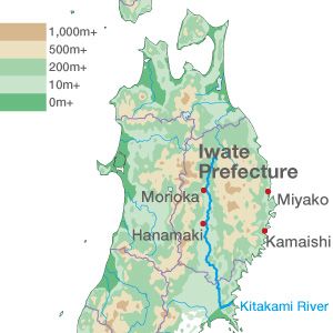
In a color-coded map, the plains would be green and the mountains brown. In the case of Iwate Prefecture, the map would be mostly brown, with a narrow strip of green running through the middle. That green is the basin of Kitakami River, which traverses the prefecture from north to south. Apart from that, the rest of the prefecture’s map is overwhelmingly brown. In particular, it is the brown of the Kitakami Highlands that dominates the entire area between the coast and the central strip of green. From this it is clear that there is simply no way that a tsunami could have traveled the roughly 100 kilometers from Miyako to Morioka (or from Kamaishi to Hanamaki).
A Mental Voyage
 When Japanese children enter junior high school, one of the things they have to buy is an atlas. It is just a basic atlas, but it still seems an exciting thing to own. Back in the days when Japanese rarely traveled overseas, or even domestically, there must have been many kids who would tirelessly pore over their atlas maps and lose themselves in daydreaming. Because travel was so uncommon, they enjoyed taking imaginary trips inspired by those maps. My uncle, who would be 100 years old if still alive today, was one of those youngsters. This map-loving boy, who later trained to become a teacher and taught at schools in rural areas, lived his whole life without really traveling at all. Yet he knew the names of places across Japan and around the world.
In this day and age, in which we can go anywhere, I suppose that people no longer look at maps the way my uncle did. Nowadays we look at maps of places to which we are headed, but not of other places. Gazing at maps is no longer a simple pastime. But it is precisely by letting our imaginations roam to picture an unvisited land and its inhabitants, even if a map is our only guide, that our hearts can be filled with sympathy. (November 22, 2011)
(Originally written in Japanese.)
Tōhoku earthquake tsunami Miyako maps Morioka Kamaishi Hanamaki Miya Kazuho