Four Years After 3/11: The State of Sanriku Today
The State of Sanriku Today (Part 1)
Society Lifestyle- English
- 日本語
- 简体字
- 繁體字
- Français
- Español
- العربية
- Русский
Rikuzentakata: Conveyor Belts in the Sky
Four years ago, I visited the city of Rikuzentakata, Iwate Prefecture, just a month after the quake. The scenes that greeted me there were otherworldly. I had viewed a number of stricken communities in the wake of the disaster, but something felt very different here.
As I viewed the landscapes through my camera’s viewfinder, I realized what that difference was: there were no heaps of rubble to be seen.
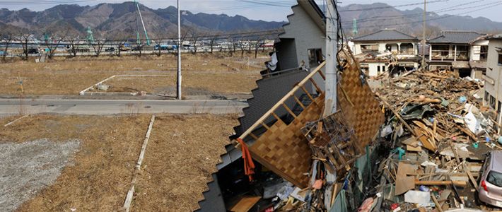
All the other tsunami zones I had visited had been covered in deep layers of wreckage. Anyone who saw scenes of the aftermath is likely to have similar images in memory. Here this wreckage was nowhere to be found, though. It had not been cleared away by human hand—in Rikuzentakata, the waves themselves carried the traces of their destruction with them when they flowed back out to sea. This, more than anything, drove home the sheer destructive force of the tsunami to me. (See photo 1.)
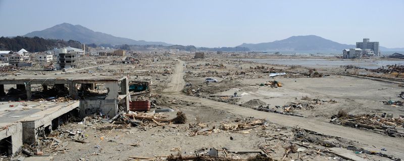 Photo 1. Rikuzentakata scrubbed bare. Taken on April 1, 2011.
The 3/11 disaster hit the entire Sanriku region hard, but Rikuzentakata saw extraordinary levels of damage. A total of 3,368 homes were damaged or destroyed, and there were 1,976 souls counted dead or missing—around 8% of the city’s population. I can still remember watching TV coverage on the night of March 11 and being chilled by the reports filed by Self-Defense Forces personnel on flights observing the afflicted region: “Rikuzentakata has been wiped off of the map.”
Today, Rikuzentakata is covered by something entirely different: elevated conveyor belts crisscrossing the empty spaces of the disaster zone. (See photo 2.) Here the rebuilding plan involves moving the city center itself to a new location, farther from the shore, and placing it at a higher elevation, atop piled-up earth. The soil is brought from nearby hills that are being leveled for their material via these conveyor belts, which span some 3 kilometers in total. Planners say this will take just a third of the time that the same operation would require if dump trucks were used to carry the earth.
 Photo 2. The Rikuzentakata conveyor-belt system. Taken on October 3, 2014.
When I visited in October 2014, a trapezoidal mound of considerable size had already taken shape. The city’s original center, though, remained empty, without a person to be seen. Above that blank space run the conveyor belts, doing their work ceaselessly, automatically.
Tarō: An Indestructible Seawall Destroyed
The Tarō district of the city of Miyako, also in Iwate, was once thought to be invulnerable to tsunami. This was not always the case—indeed, the area had a long history of being destroyed countless times by the waves. In the modern era, the Great Meiji Sanriku Tsunami of 1896 destroyed all the homes in what was then the village of Tarō, taking the lives of more than 80% of its population. In 1933, yet another quake and tsunami destroyed 90% of the homes and killed some 30% of the villagers.
▼Further reading The State of Sanriku Today (Part 2) Photographer Wada Naoki visits Kesennuma, Minamisanriku, and Onagawa to chronicle their recovery from 3/11. The State of Sanriku Today (Part 2) Photographer Wada Naoki visits Kesennuma, Minamisanriku, and Onagawa to chronicle their recovery from 3/11. |
In the following year, work began on a massive seawall to protect the community. Construction halted for a while due to the war, but in 1958 a protective structure fully 1,350 meters long, standing 10 meters above sea level, was completed at last. Further construction extended this project, turning it into a seawall of unprecedented scale, with double walls in an X-shaped form reaching around 2,400 meters in total length. Tarō (by then a town; it would become part of the city of Miyako in 2005) became known throughout Japan as a tsunami-proof community.
This designation did not survive 3/11, of course. The waves reached 15 meters in height, sweeping violently over the defenses and washing away a 500-meter stretch of the outer wall in the blink of an eye. The water advanced unchecked, doing considerable damage to the inner wall before it washed far inland, destroying the city and taking many lives. (See photo 3.)
In the area behind the failed seawall, work is now underway to raise the land elevation. (See photos 4 and 5.) Local residents are keenly aware that many were lost after placing too much faith in the gigantic concrete structure, and the majority are in favor of moving their residences to higher ground.
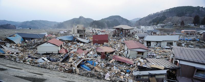 Photo 3. Destruction in the Tarō district was very nearly complete. Taken on March 30, 2011.
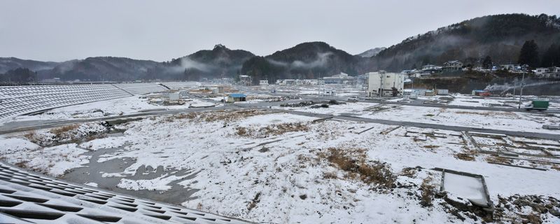 Photo 4. Winter snow covers the ground where wreckage has been removed. Taken on January 22, 2012.
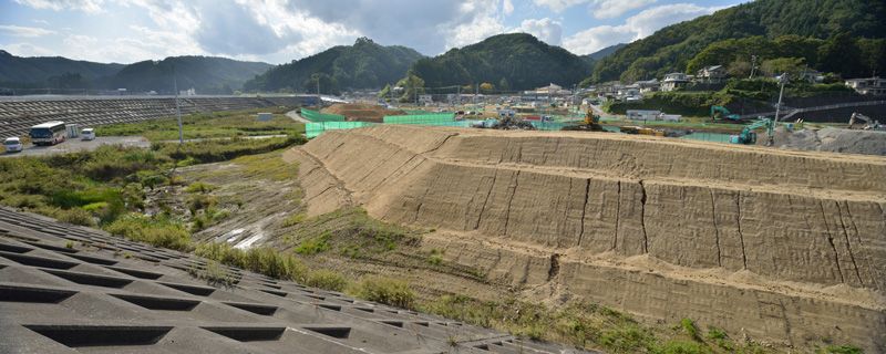 Photo 5. The newly raised earthworks will be the site of Tarō residents’ homes. Taken on October 4, 2014.
No Rest for the Dead in Ōtsuchi
The recovery and reconstruction process in the town of Ōtsuchi, Iwate Prefecture, was beset by difficulties from the very beginning. The tsunami crushed the town hall; the mayor and most of the senior officials in the municipal government were taken by the waves, never to be found. This robbed the town of its administrative functions when it needed them most.
In all, Ōtsuchi lost almost 1,300 residents in the disaster. After the tsunami destroyed the town center, fires broke out and burned much of what was left.
Photos 6 through 8 show a portion of the town center located particularly close to the hillside. After the fires died out, it remained difficult to clear away the rubble here due to the presence of the town’s cemetery underneath it. To avoid crushing the gravestones, workers removed wreckage by hand instead of with heavy machinery. By the following year the graves had been uncovered, but when the town decided to raise earthworks here and move more of the town’s central structures to this location, closer to the hills, the cemetery had to move. With the graves out of the way at last, work is now proceeding on raising the ground level.
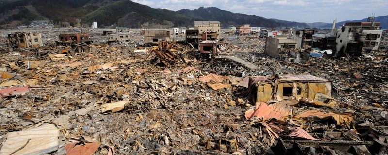 Photo 6. Scars of disaster are fresh just over a week after the quake. Taken on March 19, 2011.
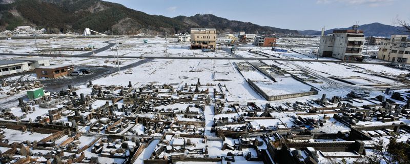 Photo 7. The gravestones stand free of the rubble and wreckage. Taken on January 23, 2012.
 Photo 8. The cemetery has moved to make way for new construction. Taken on October 4, 2014.