Four Years After 3/11: The State of Sanriku Today
The State of Sanriku Today (Part 2)
Society Lifestyle- English
- 日本語
- 简体字
- 繁體字
- Français
- Español
- العربية
- Русский
The Vanishing Ship of Kesennuma
I begin this section with a scene that should be well known to many who observed the aftermath of the March 11 disaster (photo 1). This fishing vessel, the Kyōtoku Maru No. 18, was pushed close to a kilometer inland by the tsunami, coming to rest some distance from its original berth in the fishing port of Kesennuma, Iwate Prefecture. Photo 2 shows that a year and a half after the quake, the surrounding rubble and wreckage had all been cleared away, but the boat remained sitting in the middle of what was once the city’s central district.
 Photo 1. The Kyōtoku Maru No. 18 amid the tsunami wreckage. Taken on April 1, 2011.
 Photo 2. The land has been cleared, but the boat remains. Taken on September 27, 2012.
By this point, the Kyōtoku Maru No. 18 had become something of a tourist destination. Volunteers coming to the region to help with rebuilding efforts and other visitors came to this site in a steady stream, eager to photograph this bizarre scene as a memory of the destruction of the waves. More than a few local residents suggested that the vessel be left in place as the centerpiece of a rebuilt Kesennuma commercial district, a symbol of the city’s suffering and rebirth.
In the end, though, city officials decided that leaving the Kyōtoku Maru No. 18 in place would make the municipal government responsible for its upkeep. Before anyone could find a way to make the numbers work, the vessel’s owner had it dismantled and scrapped. Since then, the Kesennuma landscape has proved far less attractive to visitors; it is a quiet, empty area now. (See photo 3.)
 Photo 3. The fishing vessel is gone, as are the tourists who came to see it. Taken on October 3, 2014.
A Breakwater to Defend an Empty Town
Next we visit the Togura district of the town of Minamisanriku, Miyagi Prefecture, which was wholly destroyed by the March 11 waves. As photo 4 shows, the seawall residents counted on to protect their community was almost completely washed away.
The town itself remains unrebuilt and unpopulated. Construction has nonetheless begun on a new seawall (photos 5 and 6). When completed, the structure will stand 8.7 meters above sea level—the frames in the photos indicate its eventual size. This undertaking will extend all the way to the shore along the hillside in the photo’s background, making it a truly monumental endeavor.
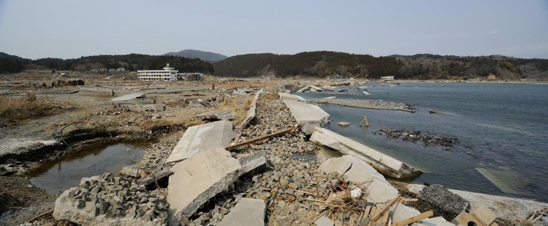 Photo 4. The wreckage of the Togura seawall. Taken on April 2, 2011.
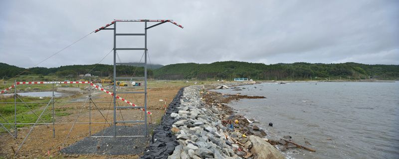 Photo 5. A rock wall is in place; the metal frame indicates the eventual height of the rebuilt wall. Taken on September 29, 2012.
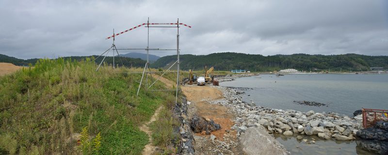 Photo 6. Work has progressed, but much remains to do. Taken on October 2, 2014.
And the residents of Togura? They will no longer live near the shore, where they once did. The community-rebuilding efforts are centered on a move to higher ground; Togura’s families are moving steadily to level plots reclaimed by the authorities in hilly areas farther inland.
Signs of Swift Recovery in Onagawa
▼Further reading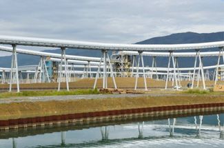 The State of Sanriku Today (Part 1) The State of Sanriku Today (Part 1) Photographer Wada Naoki visits Rikuzentakata, Tarō, and Ōtsuchi to chronicle their recovery from 3/11. |
Of all the places I have written about, the town of Onagawa, Miyagi Prefecture, is closest to the epicenter of the 3/11 earthquake. It is also the place where the recovery seems to be coming along most quickly.
Onagawa’s economy depends primarily on the Tōhoku Electric Power Company’s nuclear power station sited there and on fishing. Immediately after the disaster, the town was deeply scarred by the tsunami, just like all other coastal communities in the region. (See photos 7 and 8.) But the fishery industry has rebounded rapidly here to reach the level of catches it enjoyed before 3/11. With assistance from the Qatar Friendship Fund, the town has built a ¥2 billion fish processing and refrigeration center, the large, white structure at the center of photo 9.
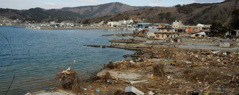 Photo 7. Rubble remains evident less than a month after the disaster. Taken on April 3, 2011.
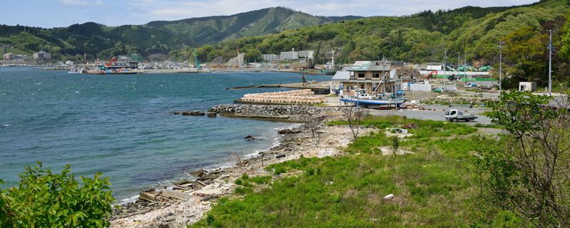 Photo 8. A year later, human activity appears to be returning to the shore. Taken on May 12, 2012.
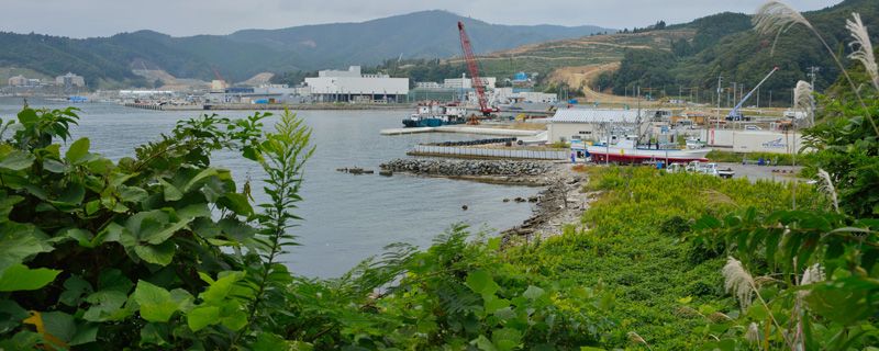 Photo 9. The Qatar-funded fish-processing plant is a highly visible symbol of Onagawa’s resurgence. Taken on October 2, 2014.
Reclamation of land along the shore, which subsided considerably in the massive earthquake, is also proceeding swiftly here. The soil used for this reclamation comes from the opposite side of the hills seen to the right of the fish-processing plant, where the trees have been cleared. Just as other places along the Sanriku coast are doing, Onagawa is leveling the very hills to raise up the land along its shoreline. But there are few places that have come so far along as Onagawa in this. Four years after that fateful day, the battered communities of Sanriku continue the long, slow process of bringing the mountains themselves to their depopulated low-lying districts.
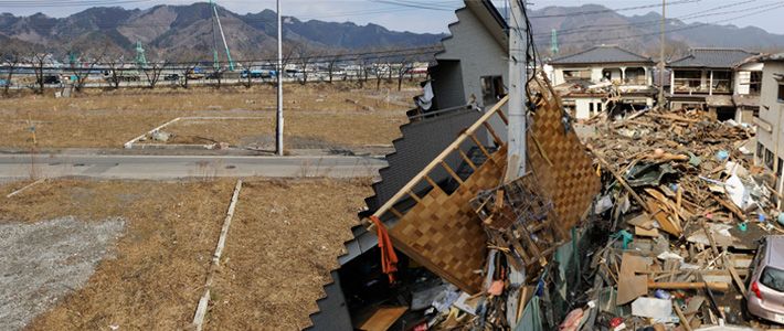
(Originally published in Japanese on March 10, 2015. Banner photos: The city of Kamaishi, Iwate, on March 31, 2011 [right], and March 17, 2014.)