The Next Big One: Government Map Forecasts Likely Future Japanese Earthquakes
Disaster Society- English
- 日本語
- 简体字
- 繁體字
- Français
- Español
- العربية
- Русский
The government Headquarters for Earthquake Research Promotion has released the 2018 Japan Earthquake Forecast Map, which summarizes predictions of seismic intensity levels and probabilities of quakes expected to occur. This map indicates the high probability of an earthquake of lower 6 intensity or above occurring within the next 30 years in southeast Hokkaidō and the Pacific Coast from the Tokyo metropolitan area to Shikoku.
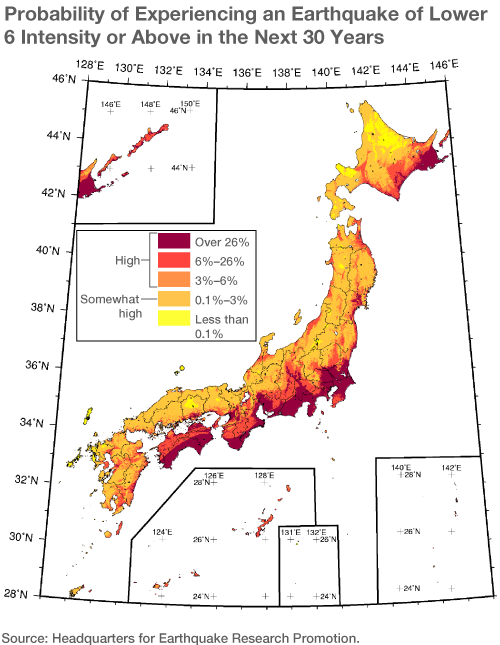
The Earthquake Forecast Map, released on an almost annual basis, is created using evaluation results of ocean trench-type earthquakes, occurring at the plate boundary between oceanic and continental plates, and fault-type earthquakes, occurring along inland active faults, as well as taking into consideration the firmness of the ground in each area.
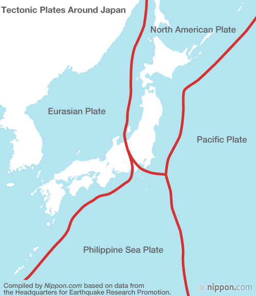
The Tokyo metropolitan area is located on three layers of plates—the North American Plate is on top, with the Philippine Sea Plate under it and the Pacific Plate underlying them both. These plates rub or collide with each other, making it a region where earthquakes regularly occur. There is also a possibility of an earthquake taking place directly under the capital, where major shakes have occurred in the past, including the 1703 Genroku Earthquake (magnitude 7.9–8.2) and the 1923 Great Kantō Earthquake (magnitude 7.9).
The probability of a lower 6 or greater seismic intensity quake occurring in a prefectural capital is highest in Chiba with 85%, followed by Yokohama at 82%, and Mito (Ibaraki Prefecture) at 81%, so the probability of an occurrence in the Tokyo metropolitan area is extremely high. Many cities in Japan are located on coastal plains originally formed by sandy sediments and clay soil deposits at the mouth of the rivers; the ground is soft and susceptible to lateral motion. Similarly, the probability is also high on the plains of the Tōkai area on the Pacific coast of central Honshū, particularly Nagoya, and the plains of the Kansai area, particularly Osaka. The area from Shikoku to Tōkai is expected to suffer damage from a large Nankai Trough earthquake, which occurs approximately every 100 to 150 years.
Probability of an Intensity 6 or Stronger Earthquake in Prefectural Capitals
| Tokyo Metropolitan Area | Chiba, Chiba Prefecture | 85% |
| Yokohama, Kanagawa Prefecture | 82% | |
| Mito, Ibaraki Prefecture | 81% | |
| Saitama, Saitama Prefecture | 55% | |
| Tokyo | 48% | |
| Tōkai Area | Shizuoka, Shizuoka Prefecture | 70% |
| Tsu, Mie Prefecture | 64% | |
| Nagoya, Aichi Prefecture | 46% | |
| Kansai Area | Nara, Nara Prefecture | 61% |
| Wakayama, Wakayama Prefecture | 58% | |
| Osaka, Osaka Prefecture | 56% | |
| Kobe, Hyōgo Prefecture | 45% |
Compiled by Nippon.com based on data from the Headquarters for Earthquake Research Promotion.
| Scale | Quake Perception and Amount of Damage |
| 0 | Imperceptible to people. |
| 1 | Felt slightly by some people. |
| 2 | Felt by many people sitting still in buildings. |
| 3 | Felt by most people in buildings. |
| 4 | Most people are startled. Hanging objects such as lights swing significantly. Unstable ornaments may fall. |
| 5 Lower | Many people are frightened and feel the need to hold onto something stable. Dishes in cupboards and items on bookshelves may fall. Unsecured furniture may move. |
| 5 Upper | Many people find it difficult to walk without holding onto something. Unsecured furniture may topple over. Unreinforced concrete-block walls may collapse. |
| 6 Lower | It is difficult to remain standing. Doors may become wedged shut. Wall tiles and windows may sustain damage and fall. Wooden houses with low earthquake resistance may lean. |
| 6 Upper | It is impossible to move without crawling. People may be thrown through the air. Most unsecured furniture moves, and is more likely to topple over. Large cracks may form, and large landslides may occur. |
| 7 | Many reinforced-concrete buildings with low earthquake resistance collapse. |
Compiled by Nippon.com based on information from the Japan Meteorological Agency
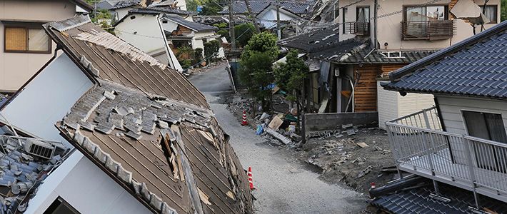
(Translated from Japanese. Banner photo: Houses that collapsed in the April 2016 Kumamoto earthquake. © Jiji.)