Major Earthquakes in Japan Since 2011
Society Disaster- English
- 日本語
- 简体字
- 繁體字
- Français
- Español
- العربية
- Русский
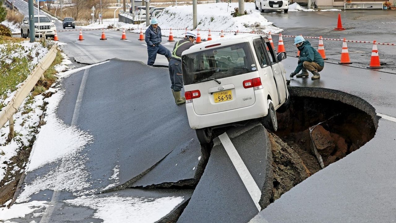
At 11:15 in the evening of December 8, 2025, an earthquake off the east coast of Aomori Prefecture caused shaking of upper 6 on the Japanese seismic intensity scale in the city of Hachinohe. The Japan Meteorological Agency estimated the quake’s magnitude as 7.6 with a hypocenter at a depth of 50 kilometers, and issued tsunami warnings for Aomori’s Pacific coast, Iwate, and Hokkaidō’s central Pacific coast. These were later lifted. Shaking of lower 6 was recorded in Aomori’s Oirase and Hashikami, and shaking of upper 5 in Mutsu, Aomori, and Hakodate, Hokkaidō.
Earthquakes of Lower 6 Intensity or Above Since the Great East Japan Earthquake
| Date (Time) | Hypocenter | Magnitude (Max. Seismic Intensity) |
|---|---|---|
| December 8, 2025 (23:15) | Off Aomori Prefecture | 7.6 (upper 6) |
| July 3, 2025 (16:13) | Off the Tokara Islands | 5.5 (lower 6) |
| August 8, 2024 (16:43) | Hyūganada Sea | 7.1 (lower 6) |
| April 17, 2024 (23:14) | Bungo Channel | 6.6 (lower 6) |
| January 1, 2024 (16:10) | Noto Peninsula, Ishikawa Prefecture | 7.6 (7) |
| May 5, 2023 (14:42) | Noto Peninsula, Ishikawa Prefecture | 6.5 (upper 6) |
| June 19, 2022 (15:08) | Noto Peninsula, Ishikawa Prefecture | 5.2 (lower 6) |
| March 16, 2022 (23:36)* | Off Fukushima Prefecture | 7.3 (upper 6) |
| February 13, 2021 (23:07)* | Off Fukushima Prefecture | 7.3 (upper 6) |
| June 18, 2019 (22:22) | Off Yamagata Prefecture | 6.7 (upper 6) |
| February 21, 2019 (21:22) | Central/eastern Iburi, Hokkaidō | 5.8 (lower 6) |
| January 3, 2019 (18:10) | Kumamoto, Kumamoto Prefecture | 5.1 (lower 6) |
| September 6, 2018 (3:07) | Central/eastern Iburi, Hokkaidō | 6.7 (7) |
| June 18, 2018 (7:58) | Northern Osaka Prefecture | 6.1 (lower 6) |
| December 28, 2016 (21:38) | Northern Ibaraki Prefecture | 6.3 (lower 6) |
| October 21, 2016 (14:07) | Central Tottori Prefecture | 6.6 (lower 6) |
| June 16, 2016 (14:21) | Uchiura Bay, off southwestern Hokkaidō | 5.3 (lower 6) |
| April 16, 2016 (9:48) | Kumamoto, Kumamoto Prefecture | 5.4 (lower 6) |
| April 16, 2016 (3:55) | Aso, Kumamoto Prefecture | 5.8 (upper 6) |
| April 16, 2016 (1:45) | Kumamoto, Kumamoto Prefecture | 5.9 (lower 6) |
| April 16, 2016 (1:25) | Kumamoto, Kumamoto Prefecture | 7.3 (7) |
| April 15, 2016 (3:46) | Kumamoto, Kumamoto Prefecture | 6.4 (upper 6) |
| April 14, 2016 (22:07) | Kumamoto, Kumamoto Prefecture | 5.8 (lower 6) |
| April 14, 2016 (21:26) | Kumamoto, Kumamoto Prefecture | 6.5 (7) |
| November 22, 2014 (22:08) | Northern Nagano Prefecture | 6.7 (lower 6) |
| April 13, 2013 (5:33) | Near Awajishima, Hyōgo Prefecture | 6.3 (lower 6) |
| April 12, 2011 (14:07)* | Central Fukushima Prefecture | 6.4 (lower 6) |
| April 11, 2011 (17:16)* | Eastern Fukushima Prefecture | 7.0 (lower 6) |
| April 7, 2011 (23:32)* | Off Miyagi Prefecture | 7.2 (upper 6) |
| March 15, 2011 (22:31) | Eastern Shizuoka Prefecture | 6.4 (upper 6) |
| March 12, 2011 (5:42) | Northern Nagano Prefecture | 5.3 (lower 6) |
| March 12, 2011 (4:31) | Northern Nagano Prefecture | 5.9 (lower 6) |
| March 12, 2011 (3:59) | Northern Nagano Prefecture | 6.7 (upper 6) |
| March 11, 2011 (15:15)* | Off Ibaraki Prefecture | 7.6 (upper 6) |
| March 11, 2011 (14:46)* | Off Sanriku area | 9.0 (7) |
* Highlighted quakes are those connected with the March 11, 2011, Great East Japan Earthquake.
Created by Nippon.com based on data from the Japan Meteorological Association.
(Originally published in Japanese. Banner photo: Rescue workers on a damaged road in the town of Tōhoku, Aomori, on December 9, 2025. © Kyōdō.)